We are now delivering all our products to your location, keeping in mind all the safety measures.
Combo of India & World Political Map on Art Paper

- Wish
- Compare
Note for Digital Maps: In case the download link is missing please note that the map is presently being updated and will be delivered to your mailbox within 24 working hours.
- Brand - Maps of India
- Product Code - MOI-P9624
- Availability - 99

India political map portrays states in different colors demarcated with state boundaries. Names of capital cities, country capital Delhi along with the neighboring countries Pakistan, Bangladesh, China, Nepal are also shown on the map. Newly formed state Telangana has also been depicted on the map. The India Political map is available in a dimension of 27.5 inches width and 33 inches height.
This vibrant world map shows the country boundaries along with National Capital and major cities. These maps are useful for classroom teaching and for examination preparation like UPSC, IAS etc. This interactive political world map is available in the size of 52 inches width and 31 inches height. These maps come in a corrugated tube so that there is no damage to the map in transit.
-
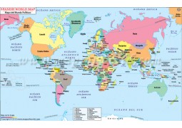
Buy Spanish World Map with Countries (Mapa del Mundo Politicos) from store mapsofindia available in vector AI(Adobe Illustrator),...
 Rs.999.00
-
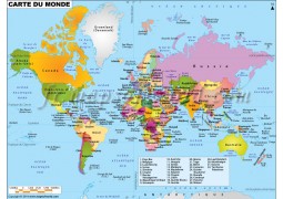
Buy french world map (Carte De Monde) from www.store.mapsofindia.com available in vector AI(Adobe Illustrator), Map availabl...
 Rs.999.00
-
Map of India detail wall map. Getting accurate and up-to-date information on India is tough, but the India Wall Map makes it eas...
 Rs.300.00
